| Back to W phase source inversion webpage |

|
|
W Phase source inversion results
3/11/2011 (Mw 9.0), Tohoku-oki, Japan
Fast and reliable moment tensor estimation
|
|
|
Zacharie Duputel (a),
Luis Rivera (a),
Hiroo Kanamori (b),
Gavin Hayes (c),
Stuart Weinstein (d) and
Barry Hirshorn (d).
(a) IPGS-EOST, CNRS/UdS, UMR 7516, Strasbourg, France.
(b) Seismological Laboratory, Caltech, Pasadena, USA.
(c) U.S. Geological Survey, National Earthquake Information Center, USA.
(d) NOAA, NWS, Pacific Tsunami Warning Center, Hawaii, USA.
|

|
|
|
|
Overview
|
The Mw 9.0 2011 Tohoku-oki earthquake happened
at 05:46 UTC (14:46 JST) on Friday 11 March
2011 near the northeast coast of Japan. The
event mechanism and the shallow centroid depth
clearly indicate a megathrust event occurring
at the boundary between the Pacific plate and
the North American plate.
We have recently developed a source inversion
algorithm using W phase at teleseismic
distances. W phase is a very long period phase
(mainly 100s-1000s) arriving at the same time
as the P wave. When the displacement
seismograms are filtered between 100s and
1000s, it is conspicuous between the P wave
and the surface waves. Because of its long
period nature and because it precedes the
large amplitude surface-wave arrivals, the W
phase can provide rapid and reliable estimates
of the overall source parameters of large
events. This contrasts with other source
inversion methods which usually take several
hours to determine the first order attributes
of a great earthquake (i.e. Mw>8.5) even in a
well instrumented region.
The W phase
source inversion algorithm is now running
online at U.S. Geological Survey (USGS),
at the Pacific Tsunami Warning Center (NOAA/NWS/PTWC)
and at the Institut de Physique du Globe de Strasbourg
(IPGS-EOST, CNRS/UdS).
The W phase solution calculated at PTWC is
issued internaly within 30 minutes after
origin time (O.T.) in order to have a quick
preliminary robust estimate of the event
magnitude and focal mechanism of large
earthquakes. The W phase solution computed at
USGS is made available on line for each significant
event. (e.g. Tohoku-oki 2011 earthquake).
The figure below shows the
updated W phase
solution computed with a selection of "low
noise" stations showing the best signal to
noise ratios. This solution yields a moment
magnitude Mw=9.0 with a quasi pure
double-couple mechanism showing a small dip
toward the west. The optimum W phase centroid
location is 37.92°N, 143.11°E at a depth of
19.5 km and the best double couple is
[Strike=196°, Dip=12°,
Rake=85°] which is in very good agreement
with the subduction interface geometry given
by SLAB1.0 (G. Hayes, USGS).
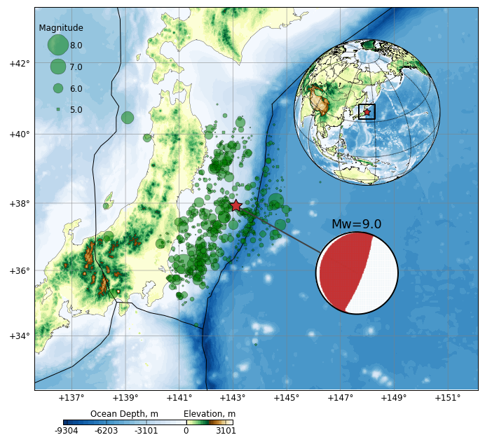
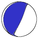
W phase CMT solution obtained for the 2011 Tohoku-oki
earthquake. The green circles correspond to USGS
location of events occurring between 2011-03-11 and
2011-03-20.
|
|
|
Preliminary results
|
The first preliminary magnitudes provided by
the different agencies within 15 min after the
event origin time (O.T.) are clearly
underestimating the actual event size as it is
generally the case for large events. The PTWC
first Mwp estimate gave an Mw=7.5, the USGS
announce an M=7.9 in its preliminary
earthquake report and the
European-Mediterranean Seismological Center
(EMSC) rapid determination of source
parameters yield to Mw=8.0. The table below
show the results delivered by real-time
implementations of the W phase algorithm at
the Pacific Tsunami Warning Center
(NOAA/NWS/PTWC), the U.S. Geological Survey
(USGS) and at the IPG Strasbourg (IPGS-EOST,
CNRS/UdS). The PTWC and IPGS W phase solutions
are implemented for internal use only while
the USGS W phase solution is routinely
disseminated to the public.
The automatic trigger of the W phase
algorithm at USGS and PTWC quickly yielded an
Mw>=8.8 (20, 22min and 30min after O.T.) which
is significantly larger than the initial
magnitudes provided by PTWC, USGS and
EMSC. The magnitude Mw=8.8 obtained at PTWC is
still lower than the final moment magnitude
because of the large depth assumed initially
in the automatic process (depth=83.5km). A
manual trigger at PTWC 40 min after the origin
time using a centroid depth at 24km yielded a
more reasonable magnitude Mw=9.0 with a
dip=12°. The first USGS W phase solution
which was publicly disseminated 1 hour after
O.T. gave Mw=8.9 with a larger
dip=16°. The two last real-time W phase
solutions provided by IPGS and USGS show very
similar magnitudes and dips (i.e. Mw=9.0,
dip=14°).
|
|
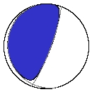
20min after O.T: USGS Internal W phase solution (6 channels)
Mw=9.0
Centroid loc.: Lat= 36.82N; Lon= 142.87E; Dep= 24.4 km
Time delay = Half duration = 68.7 sec
Best Double Couple: M0=3.941E+29 dyn.cm
NP1: Strike=222.7 ; Dip=16.8 ; Slip=134.6
NP2: Strike=356.8 ; Dip=78.1 ; Slip=78.0
|
|
|
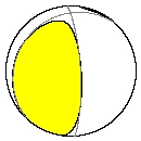
22min after O.T: PTWC Automatic W phase solution (29 channels)
Mw=8.8
Centroid loc.: Lat= 39.00N; Lon= 142.80E; Dep= 83.5 km
Time delay = Half duration = 56.0 sec
Best Double Couple: M0=1.934E+29 dyn.cm
NP1: Strike=165.4 ; Dip=10.3 ; Slip=55.3
NP2: Strike=20.5; Dip=81.6 ; Slip=95.9
|
|
|
30min after O.T.: PTWC Automatic W phase solution (74 channels)
Mw=8.8
Centroid loc.: Lat= 38.30N; Lon= 143.50E; Dep= 83.5 km
Time delay = Half duration = 68.0 sec
Best Double Couple: M0=1.775E+29 dyn.cm
NP1: Strike=194.3 ; Dip=22.8 ; Slip=81.3
NP2: Strike=23.7 ; Dip=67.5 ; Slip=93.6
|
|
|
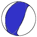
40min after O.T.: PTWC Manual W phase solution (105 channels)
Mw=9.0
Centroid loc.: Lat= 38.40N; Lon= 142.90E; Dep= 24.4 km
Time delay = Half duration = 69.0 sec
Best Double Couple: M0=4.325E+29 dyn.cm
NP1: Strike=190.6 ; Dip=11.1 ; Slip=76.7
NP2: Strike=24.2 ; Dip=79.1 ; Slip=92.6
|
|
|
48min after O.T: USGS Internal W phase solution (74 channels)
Mw=8.9
Centroid loc.: Lat= 37.82N; Lon= 142.87E; Dep= 24.4 km
Time delay = Half duration = 72.2 sec
Best Double Couple: M0=3.225E+29 dyn.cm
NP1: Strike=204.4 ; Dip=14.8 ; Slip=104.3
NP2: Strike=9.7 ; Dip=75.7 ; Slip=86.3
|
|
|
1hour after O.T.: USGS Published W phase solution (89 channels)
Mw=8.9
Centroid loc.: Lat= 38.32N; Lon= 141.77E; Dep= 24.4 km
Time delay = Half duration = 48.0 sec
Best Double Couple: M0=2.836E+29 dyn.cm
NP1: Strike=162.0 ; Dip=16.9 ; Slip=45.1
NP2: Strike=28.2 ; Dip=78.1 ; Slip=102.1
|
|

|
1hour 30min after O.T.: IPGS W phase solution (146 channels)
Mw=9.0
Centroid loc.: Lat= 38.12N; Lon= 142.97E; Dep= 24.4 km
Time delay = Half duration = 72.0 sec
Best Double Couple: M0=3.507E+29 dyn.cm
NP1: Strike=196.3 ; Dip=14.4 ; Slip=85.1
NP2: Strike=21.4 ; Dip=75.7 ; Slip=91.3
|
|
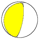
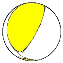
Real-Time W phase CMT solutions
obtained for the 2011 Tohoku-oki earthquake. The blue
mechanisms indicate the solutions obtained at
PTWC, the yellow mechanisms correspond to USGS
solutions and the green mechanism indicate the
IPGS automatic solution.
|
|
|
Updated results
|
We retrieved the LHZ, LHN and LHE waveforms
belonging to FDSN, GSN and STS1 global virtual
networks using the IRIS DMC facilities. Most
of the channels used belong to BK, CI, CN, G,
GE, IC, II, IU, MN and US networks.
Before trying a formal inversion for
the moment tensor we perform a first-order fit
of the W phase amplitude as a function of
distance and azimuth. The idea here is to
capture the information carried by the overall
vertical amplitude of W phase and to translate
it into magnitude. After reduction to a common
distance, the peak-to-peak amplitudes are
matched to a simple two lobed azimuthal
pattern which accounts for variation due to
the mechanism.
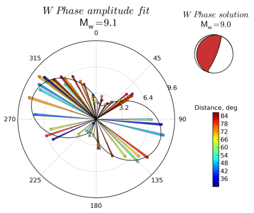
The figure on the right shows the
amplitude-azimuth fit once the distance
correction has been applied. The continuous
line presents the result of the regression
while the colored bars indicate the corrected
peak-to-peak values which are measured at
different epicentral distances. The average
amplitude is estimated here to be 5 mm and the
corresponding preliminary magnitude is
Mw=9.1. We also note that the orientation of
the lobes agrees well with the fault strike.
|
|
W phase
preliminary amplitude fit for the
2011 Tohoku-oki earthquake. A polar
representation is used: the angle
and radius correspond respectively
to the station azimuth and amplitude
value. The continuous line represent
the result of the regression
determined from W phase
amplitudes. The updated W phase
centroid moment tensor (WCMT)
solution is displayed for
comparison.
|
|
|
Since this event is characterized by a shallow
centroid depth (i.e. shallower than 30km), the
W phase solution can be potentially affected
by the trade-off between the dip and the
scalar moment. To cope with this situation,
one possibility is to carefully select low
noise stations to constrain best the moment
tensor elements controlling the fault dip.
A first rough screening is preformed
first in order to reject the worst stations
(median screening, misfit screening). The
noise level is then computed for all the
remaining channels using the 3 hour-long
signal preceding the 2011 Tohoku-oki event. We
then select 96 low noise channels showing an
average noise level within 30dB of the New Low
Noise Model (NLNM) in the 1-5mHz
passband. Using this optimum dataset, we
estimate the moment tensor as well as the
centroid latitude, longitude, depth and
timing.
The figures below show the updated W
phase CMT (WCMT) inversion results. The W
phase waveform and later arrivals are very
well fitted by the data predicted from the
WCMT solution. The optimum centroid depth of
20km as well as the dip of about 12°
agrees very well with the SLAB1.0 geometry in
this region (Gavin Hayes, USGS). The
difference between the W phase magnitude
Mw=9.0 and the Global CMT Mw=9.1 can be fully
explained by the dip difference beween the two
source models (i.e. gCMT dip is 10° and
the WCMT dip is 12°). If we fix the gCMT
dip to 12°, the gCMT magnitude becomes
similar to WCMT with Mw=9.0. However, since
the fault ruptured over several hundred
kilometers down-dip with significant variation
of dip, a strict interpretation of dip of a
point source is not meaningful.
Updated W phase solution
|
Mw: 9.0
latitude : 37.92°N
longitude: 143.11°E
depth : 19.5 km
Time delay : 68.0 sec
Half duration: 68.0 sec
96 channels (69 stations)
Moment tensor: scale= 1.0E+29 dyn.cm
rr= 1.695 ; tt=-0.147 ; pp=-1.548
rt= 1.403 ; rp= 3.637 ; tp=-0.534
Principal Axes:
1.(T) Val= 4.242 ; Plg= 57 ; Azm=292
2.(N) 0.031 ; 1 ; 201
3.(P) -4.273 ; 33 ; 110
Best Double Couple: M0=4.26E+29 dyn.cm
NP1: Strike=196 ; Dip=12 ; Slip= 85
NP2: Strike= 21 ; Dip=78 ; Slip= 91
|

DOWNLOAD SOLUTION
(CMTSOLUTION format)
|
|
|
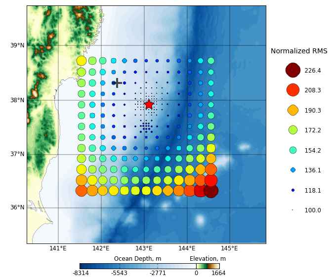
W phase
centroid position grid-search
for the 2011 Tohoku-oki
earthquake. The black cross
indicates the USGS PDE
location while the red star
shows the optimum W phase
centroid location.
|
|
|
|
|
|
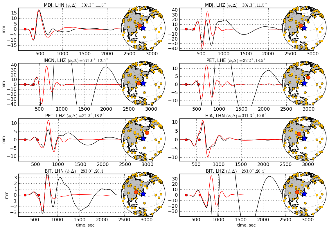
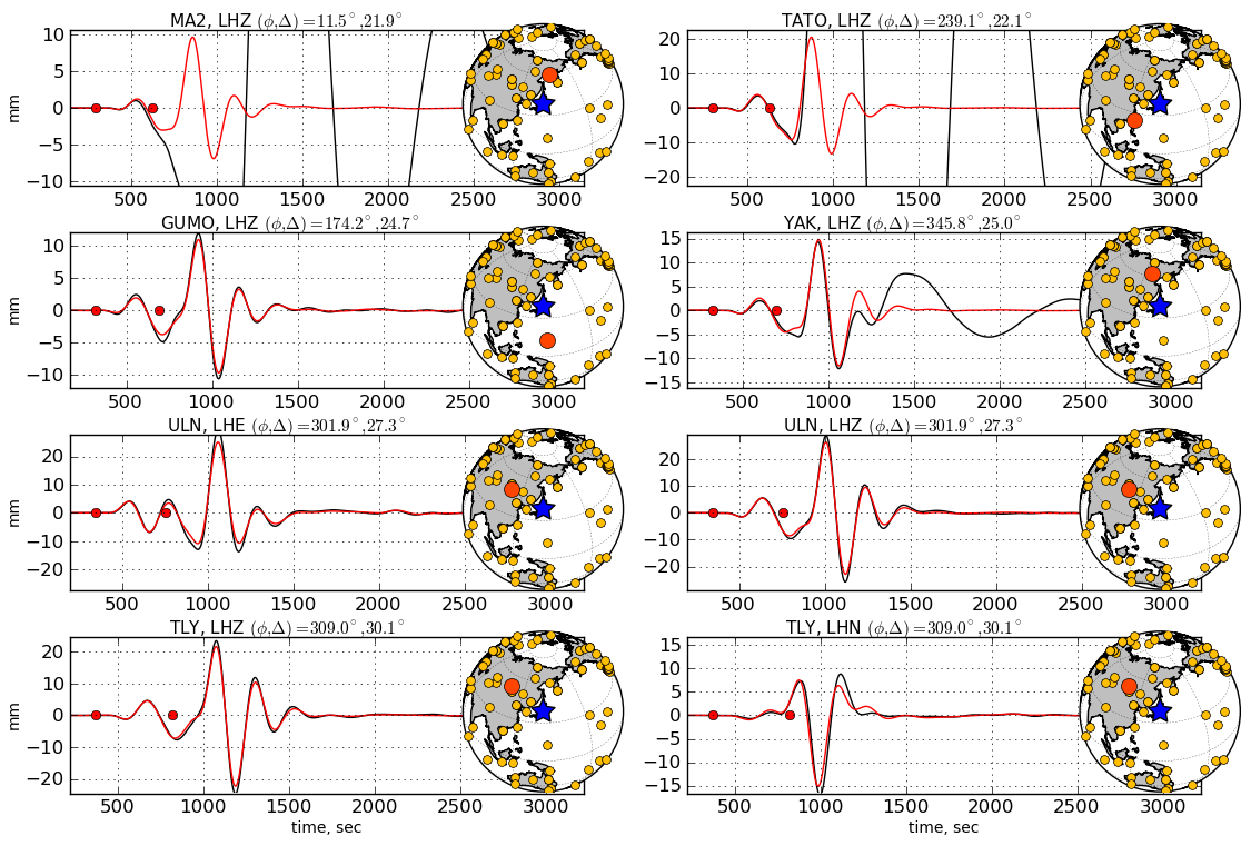
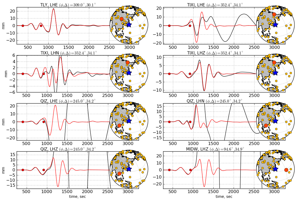
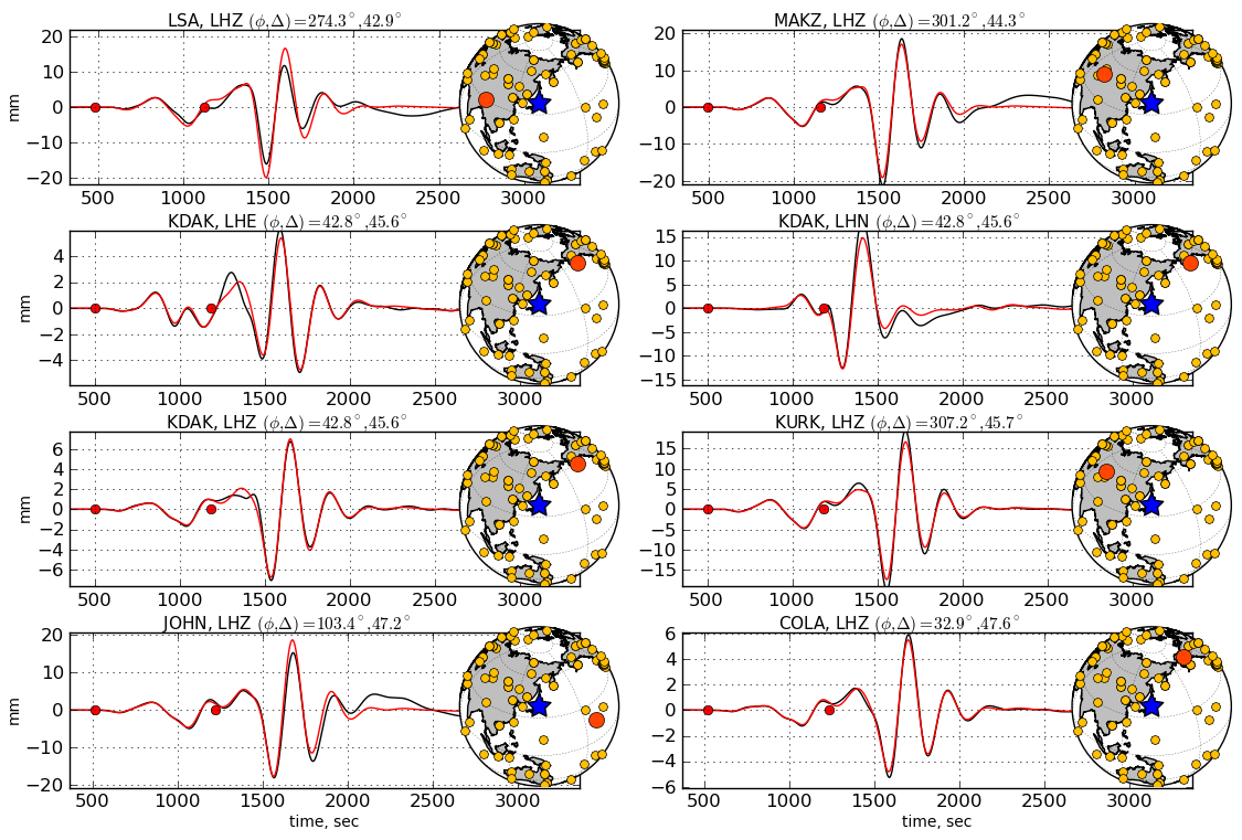
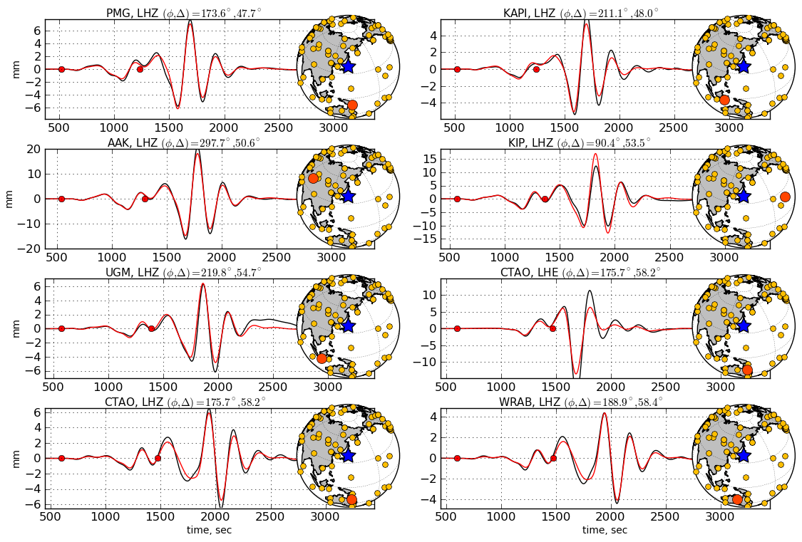
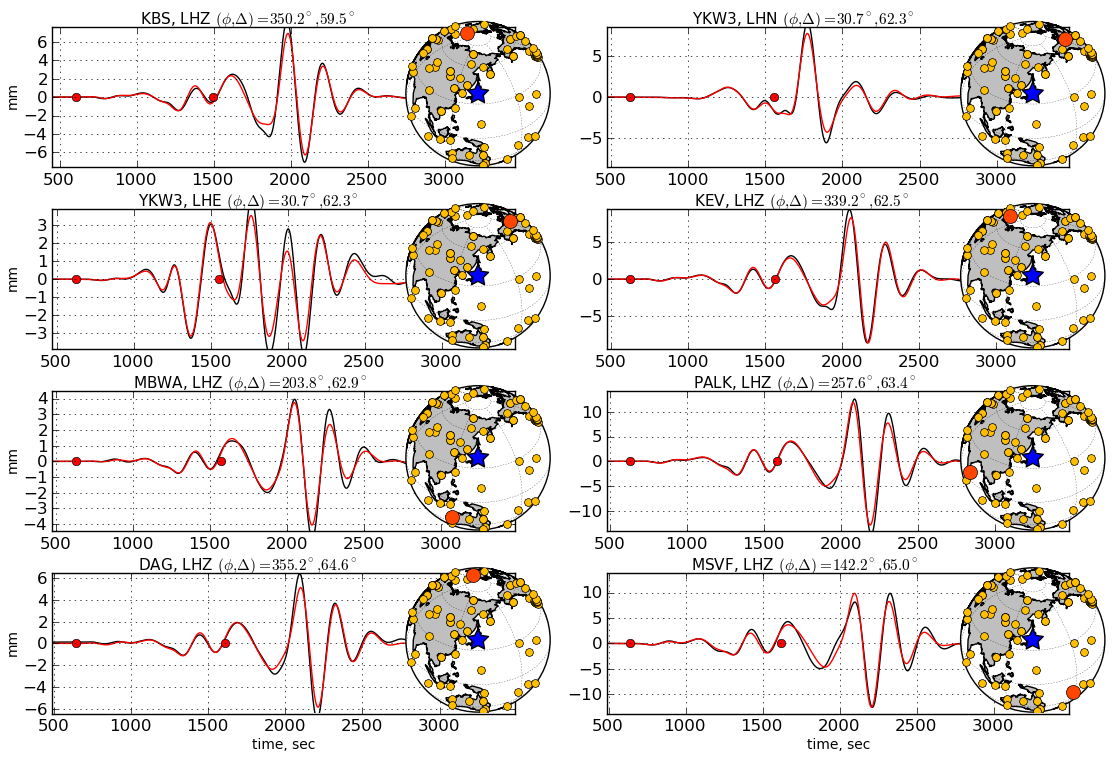
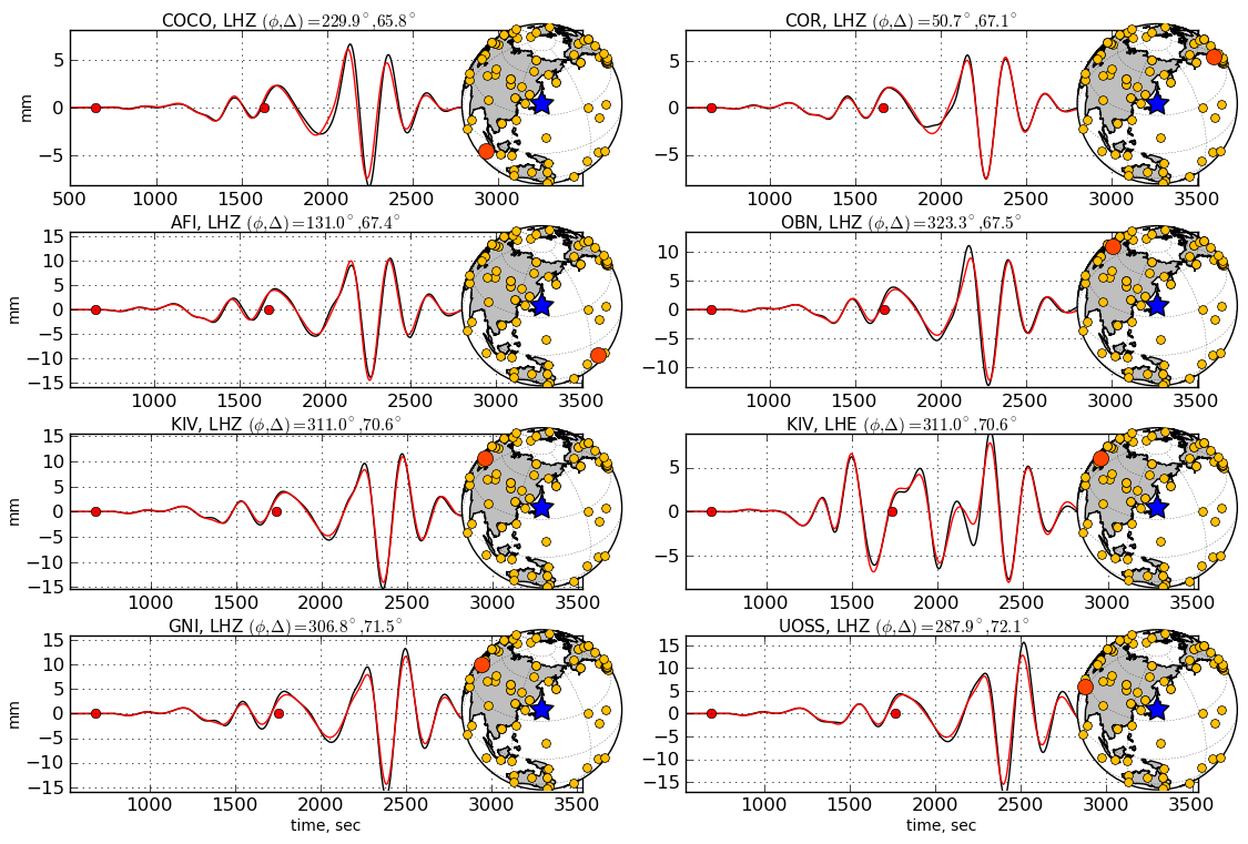
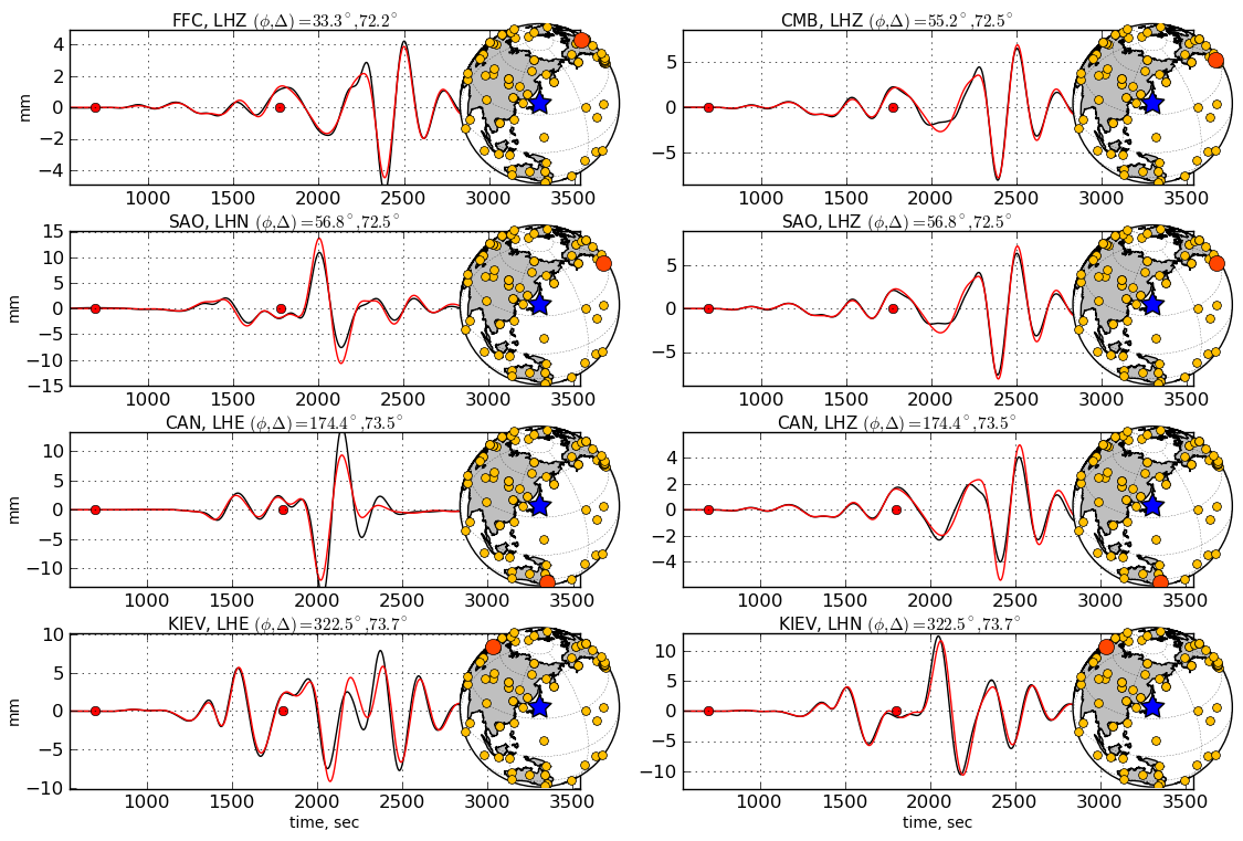
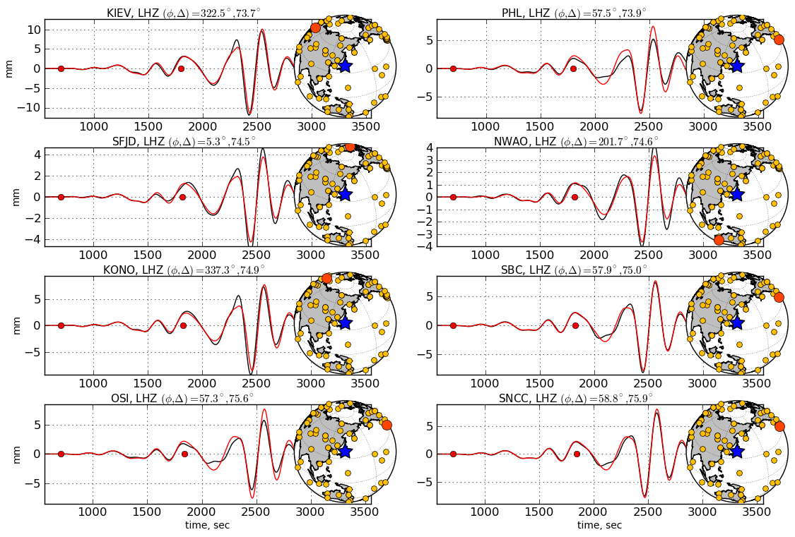
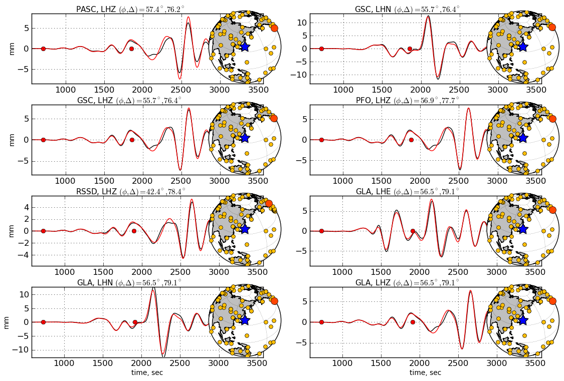
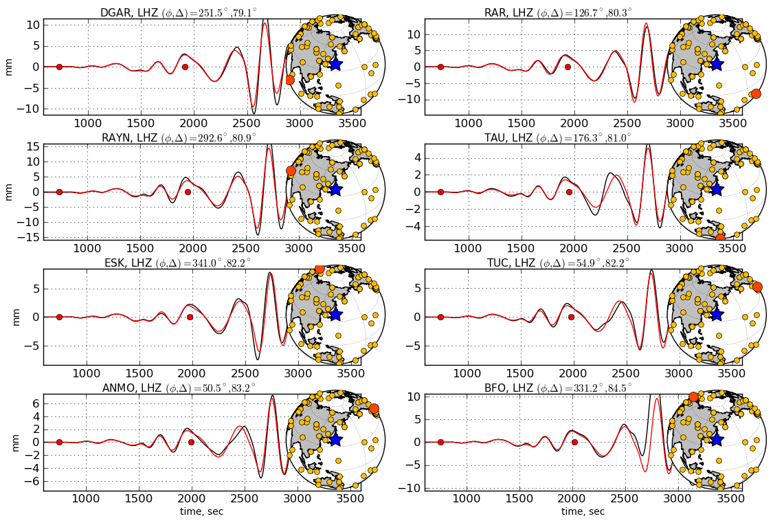
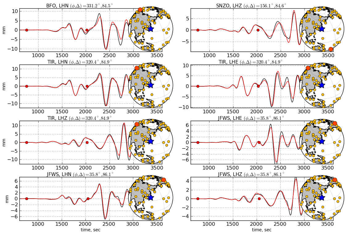
Comparison of observed
waveforms (black) and the corresponding
synthetics (red) computed from the W phase
updated CMT solution. The station azimuth
(Φ) and epicentral distance (Δ)
are indicated as well as the W phase time
windows which are bouded by red dots. The W
phase CMT inversion is based on the ground
motion of stations within Δ<90°
after applying a passband filter in the
1-5mHz passband. W phase and later arrivals
are very well predicated by the W phase CMT
solution. For some stations like INCN, PET,
BJT, MA2, TATO, YAK and QIZ, the surface
waves are affected by instrument problems
while the W phase is not affected.
|
|
|
Links and References
Articles
Kanamori, H., 1972. Mechanism of tsunami earthquakes, Phys. Earth Planet Inter.,
6, 356-359.
Kanamori, H. & Rivera, L., 2008. Source inversion of W phase: speeding tsunami
warning, Geophys. J. Int., 175, 222-238.
Hayes, G., Rivera, L. & Kanamori, H., 2009. Source inversion of the W phase:
real-time implementation and extension to low magnitudes, Seismol. Res. Let.,
3, 800-805.
Z. Duputel, L. Rivera, H. Kanamori, G. Hayes, 2011.
W-phase fast source inversion for moderate to large earhquakes
(Mw>=6.5, 1990 - 2010), Geophys. J. Int., submitted
|
|
W phase solutions
USGS W phase solution
ERI W phase solution
|
|
Data sources
IRIS Data Management System, and specifically
the IRIS Data Management Center, were used for
access to waveform and metadata required in
this study (http://www.iris.edu).
Global Seismographic Network (GSN) is a
cooperative scientific facility operated
jointly by the Incorporated Research
Institutions for Seismology (IRIS), the United
States Geological Survey (USGS), and the
National Science Foundation (NSF).
(http://www.iris.edu/hq/programs/gsn).
Geoscope operated by the Institut de Physique
du Globe de Paris (IPGP) and the Ecole et
Observatoire des Sciences de la Terre (EOST)
(http://geoscope.ipgp.fr).
The GEOFON network funded and operated by GFZ
Potsdam, Germany, in co-operation with almost
50 institutions worldwide.
(http://geofon.gfz-potsdam.de/geofon).
The Mediterrean Network (MedNet) mantained by
INGV in cooperation with many geophysical
institutes.
(http://mednet.rm.ingv.it).
Northern California Earthquake Data Center
operated by Berkeley Seismological Laboratory
and USGS (http://www.ncedc.org).
Southern California Seismic Network operated
by Caltech and USGS
(http://www.scsn.org).
Canadian National Seismograph Network (CNSN)
mantained by the Geological Survey of Canada
(http://earthquakescanada.nrcan.gc.ca).
|
|
Back to W phase source inversion webpage
|
|
|


|