CASE-IPY : Concordia Antarctic Seismic Experiment for the International Polar Year

The CASE-IPY project is a part of a larger IPY initiative, the
Polar Earth Observing Network (POLENET), which includes
contributions from 24 countries, including France, Italy,
Australia and the United States.
The aim of the POLENET consortium is to investigate polar geodynamics,
the Earth's magnetic field, crust, mantle and core structure and
dynamics, and systems-scale interactions of the solid earth, the
cryosphere, the oceans and the atmosphere. Activities will be focused
on deployment of autonomous observatories at remote sites on the
continents and offshore, coordinated with measurements made at
permanent station observatories.
We plan to deploy 7-10 broad-band seismometers in East Antarctica,
using Concordia / Dome C as our starting point. Our deployment will be
coordinated with those of our international
colleagues in order to achieve maximum coverage of the East Antarctica
Plateau, and to share a maximum of logistical support.
Three of the stations were deployed during the 2007-2008 summer campaign as prototypes for the full IPY deployment. Four stations from the full deployment were installed during the 2009-2010 summer campaign. See below for details about both deployments.
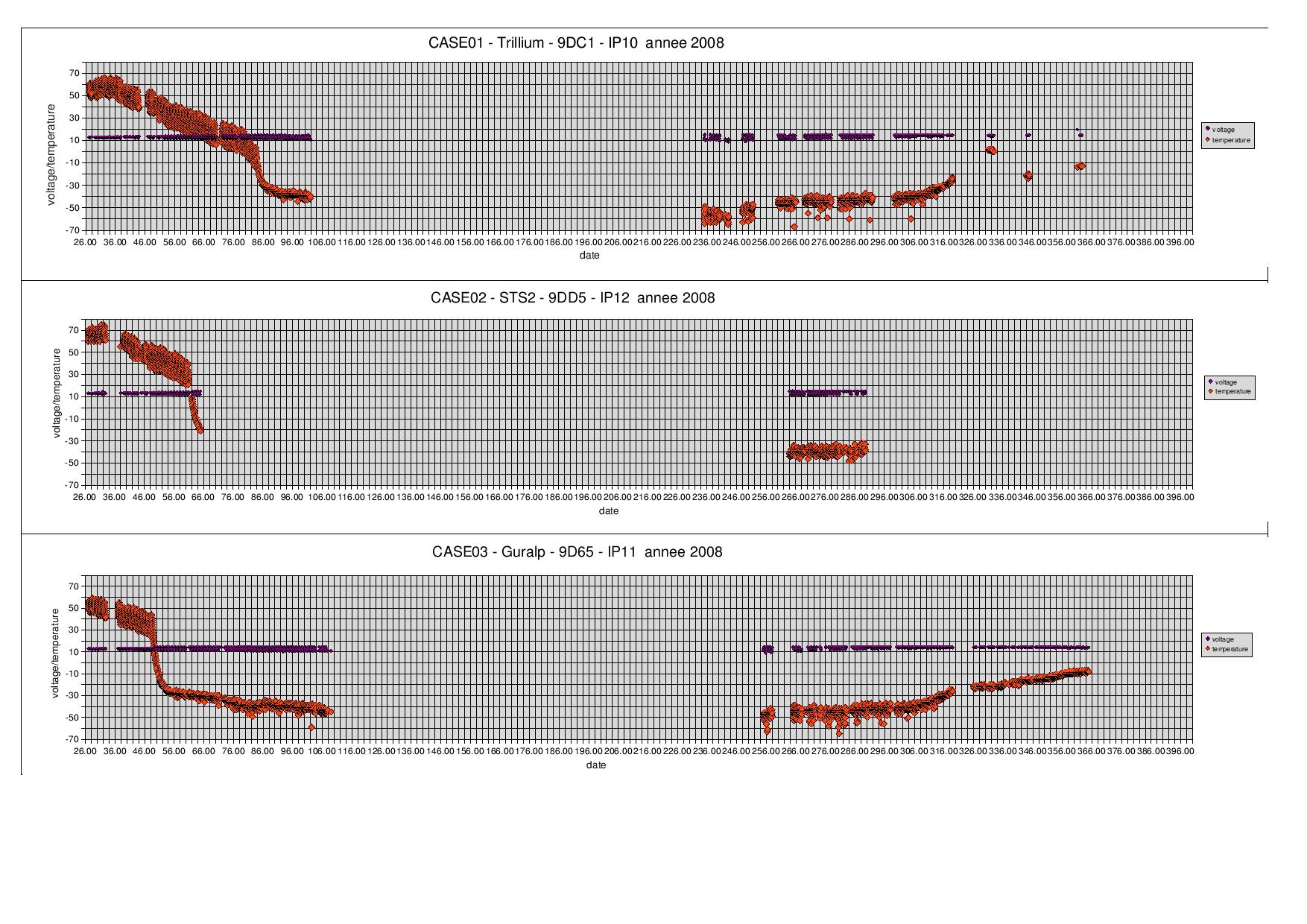
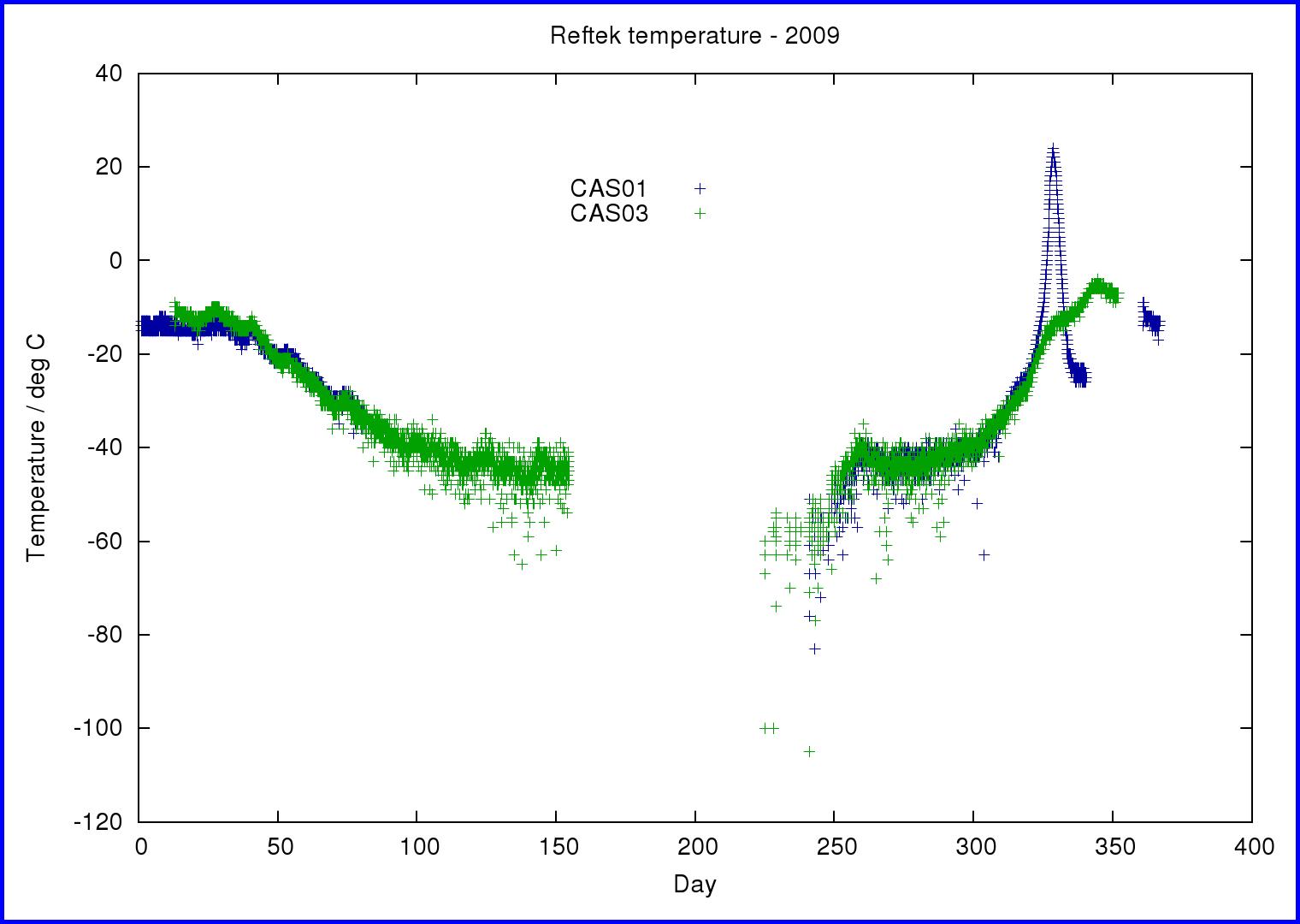
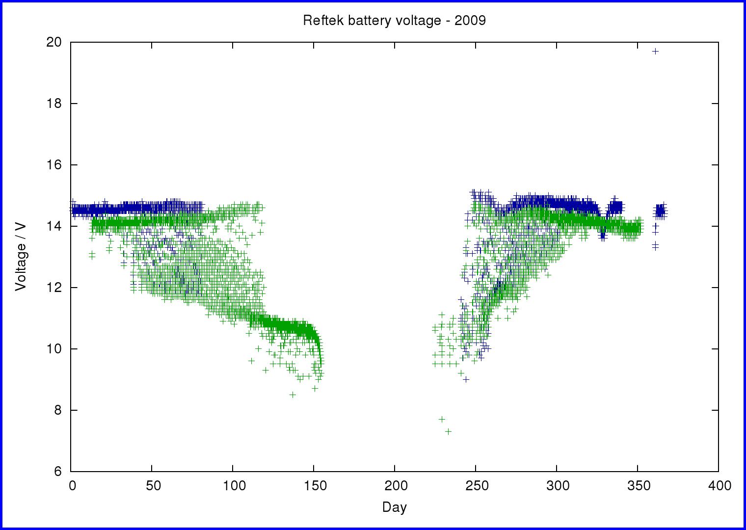
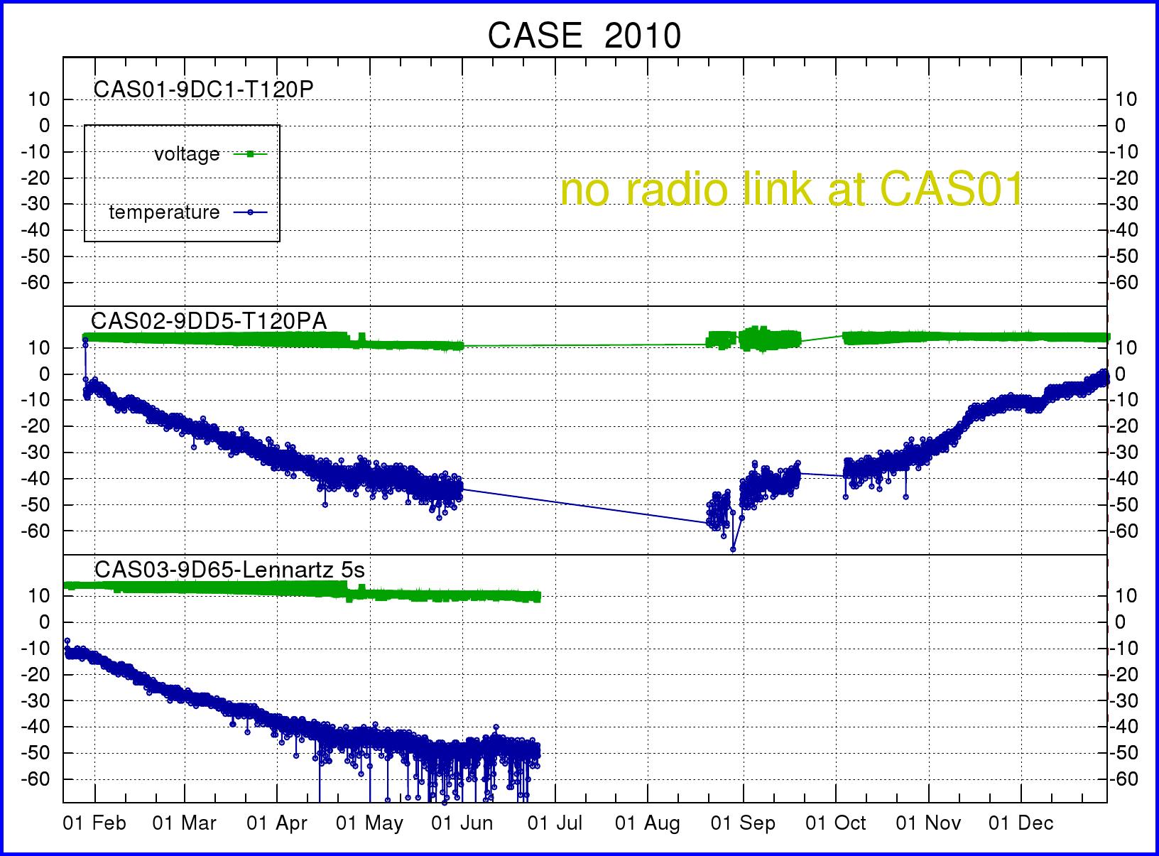
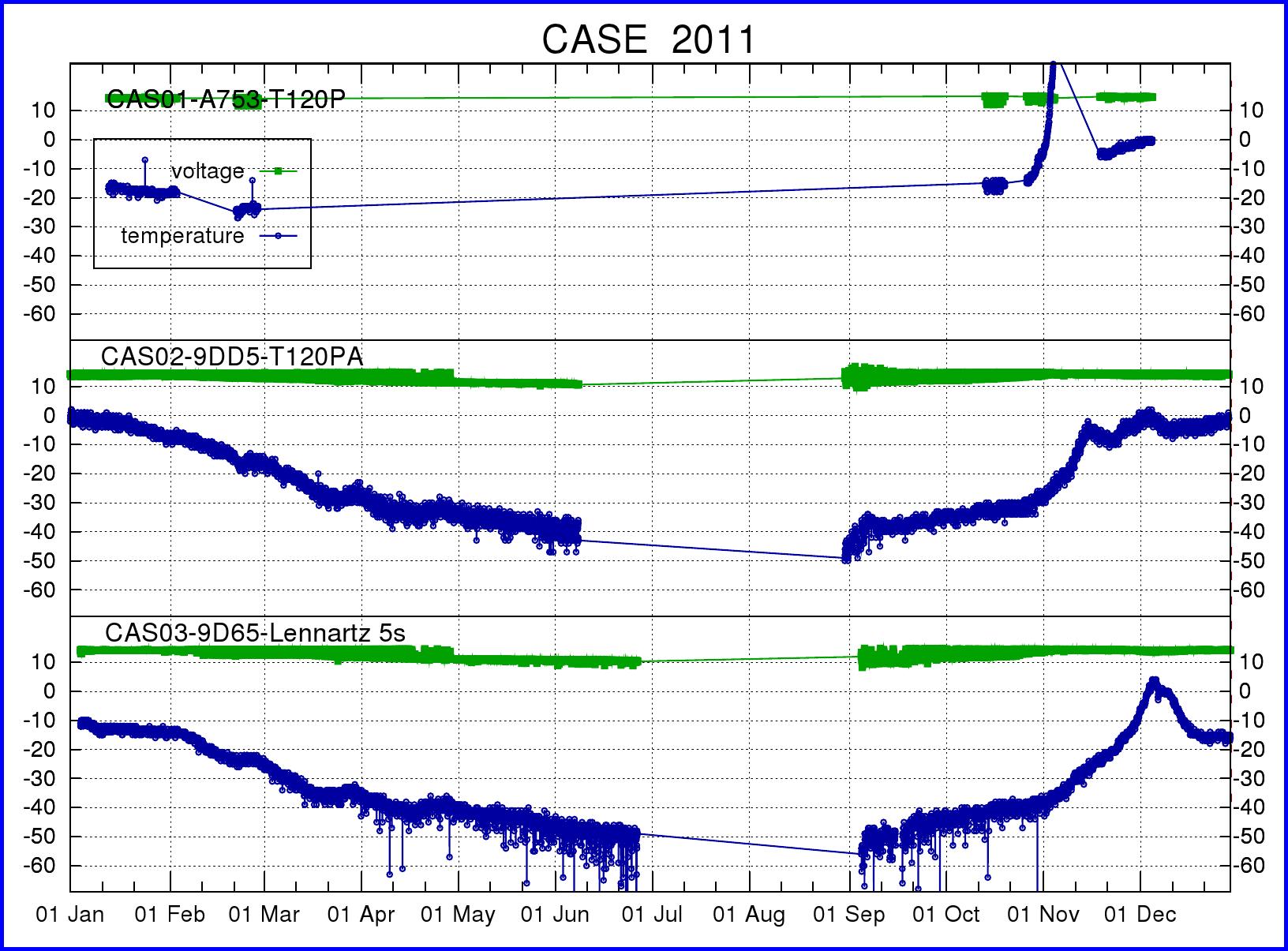
You can find the available SOH (state of health) information for the three
prototype stations in these pdf files (2008.pdf ,
2009.pdf),
2010.pdf)
2011.pdf)
or in the following images.
The symbols indicate the temperature and the input power voltage seen by the
RefTek acquisition systems in each of the three stations.
The horizontal axis represents time in days from January 1st.
Click on images for larger versions.
We are very fortunate in being able to receive daily data updates from two of our
prototype CASE-IPY stations (CAS02 and CAS03). The following pdf files contain daily snapshots
of the 1sps data (Z=vertical component, N=North-South component, E=East-West
component):
CAS02.Z , CAS02.N , CAS02.E
CAS03.Z , CAS03.N , CAS03.E
The following image shows the vertical component seismograms of the latest
available data for the two stations. Click on images for a larger
versions.


We populate a database of CMT events of M6.3 and greater.
These pdf files (
2008 ,
2009 ,
2010
2011
) show the raw, one sample per second, three component seismograms for the
global events we have detected.
2009-2010 Summer Campaign
During the 2009-2010 summer campaign, we recovered all the 2009 data for the three prototype stations, and carried out routine maintenance (replacement of defective parts) and upgrades.
We also installed four out of five autonomous stations on a profile extending from Concordia to Vostok. The installations were carried out using a Twin-Otter aircraft, by a 4-person team working 3-4 hours at each site:
CAS04 S 75° 42.9661 E 120° 13.5446'
CAS06 S 76° 50.4580' , E 112° 59.2026'
CAS07 S 77° 40.6726' , E 110° 32.9755'
CAS08 S 78° 24.5371' , E 107° 07.1868'
As you can tell by the numbering, we are missing CAS05, which we hope to install next year in the vicinity of (S 76° 20.830' , E 116° 58.060'). More information about the deployments is available (in French) in an article on the IPEV website.
2008-2009 Summer Campaign
During the 2008-2009 summer campaign, we recovered all the 2008 data for the three prototype stations, and carried out routine maintenance (replacement of defective parts) and upgrades.
2007-2008 Summer Campaign
The 2007-2008
summer campaign is now over, and it is time to take stock,
analyze the preliminary data from the CASE-IPY experiment, and start
planning next year's campaign.
The objective of the 2007-2008 summer campaign was to complete and
deploy three
prototype autonomous seismic stations around Concordia. The three
stations have been deployed at the following coordinates, from which
they transmit part of the data they record to Concordia via radio
link:
CAS01 : S75° 08.0414' , E123° 16.0849'
CAS02 : S75° 03.8448' , E123° 14.7480'
CAS03 : S75° 06.8405' , E123° 28.5318'